1885 Saybrook Point
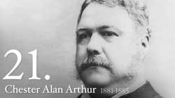
 In 1885, Chester A. Arthur was the 21st President of the United States, succeeding James A. Garfield following the death of the 20th President on September 19, 1881 at age 49 (Garfield was shot on July 2, 1881 and died a little over two months later). President Arthur was known, among other things, for instituting the first general Federal immigration law in 1882 which excluded “paupers, criminals and lunatics” from entry into the US.
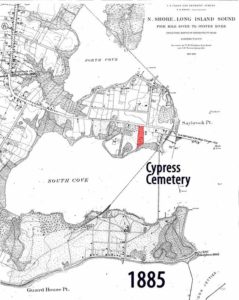
A close look at the 1885 U.S. Coast and Geodetic Survey map reveals numerous interesting features. See if you can pick out more than the following:
-
- Cypress Cemetery Property Outline
The ancient burial ground (highlighted in red), now known as Cypress Cemetery, is clearly depicted on this map. By 1885, the cemetery had been in existence for well over 200 years with the first marked grave dating back to 1685. Note that the cemetery’s newer “annex” area immediately west(left) of the original burial ground is shown as what appears to be orchards. The area adjacent to College Street, which is today occupied by the Yale memorial boulder, also appears to be orchards. In that descriptions of the 16 acres owned by Colonel George Fenwick included what sounded like substantial orchards, it is possible that those shown on the map adjacent to Cypress Cemetery are perhaps remnants of the Fenwick’s original fruit trees, or trees replanted within the orchard.
-
- Extension of the Railroad to Saybrook Point and Fenwick.
It was the construction of the railroad that leveled the area at the riverfront where the colony’s gun mound stood near the present location of the Dock & Dine Restaurant. Further, Lady Fenwick’s original tomb and Tomb Hill were removed from this area to make way for the railroad’s riverfront facilities as well. All of the sand and gravel was used to construct the present day causeway from Saybrook Point to the Borough of Fenwick.
-
- Samuel Willard House, Colonel Fenwick and Yale
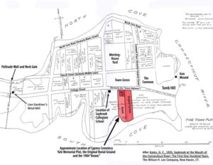
 On a reproduced version of the Gilman Gates 1935 Town Plat, a single structure is seen located at the southeast corner of College Street and Willard Avenue with what appears to be orchards around it. It is the house at that corner – the Samuel Willard House located approximately 400 feet west (left on the map above) of the cemetery – which is thought to have been built atop the old foundation of the Saybrook Collegiate School, later to be known as Yale University when relocated to New Haven in 1717.
Comparision of 1838 and 1885 Maps
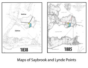
 When the 1838 and 1885 maps are compared, an interesting difference can be seen in the angle of College Street as it passes from west to east in front of the cemetery. Between 1838 and 1885, the “highway” appeared to be diverted slightly south and extended toward the river and past the cemetery. Also note the difference in the angle and location of Cromwell Street as it enters College Street just east of Cypress Cemetery. In 1838, the intersection looks like a sharp curve to the north whereas in 1885, the roadways intersect at a 90 degree angle. The intersection is to the northwest of the cemetery in 1838 and to the east in 1885. The fact that College Street appears to be located further north in the 1838 map would potentially explain why some of the original gravesites, including that of Matthew Griswold, are said to be located under the paved portion of College Street and not within the present boundary of the property. That area was likely a part of the original “ancient” burial ground.